dimecres, 27 d’abril del 2011

SEAQUAKES OR TSUNAMIS


The undersea earthquakes cause movements of sea water (tidal waves or tsunamis). Tsunamis are a series of tidal waves, earthquakes product at the bottom of the sea or near coastal areas, the collapse of large masses of ice on land or sea or a lake, and occasionally may result from collapse the crater of a volcano located near or below sea level. Are also called tsunamis. On approaching the shore with his strength and huge size, the waves burst with destructive force, being able to disappear populations found on the shore. We know that is not the first wave that causes the most damage, and his strength is less than the following.
The truth is that tsunamis are the result of submarine volcanic eruptions and earthquakes that shake the planet. Tsunamis cross the ocean in the form of low waves, often without the ships on the high seas are perceived, because the speed with which slide reaches to 270 km per hour at 15 minute intervals. Approaching the beach on a huge rise (with waves of 18 meters and 30 meters aplaceradas areas in the coves) and burst with destructive force, but not always the first is what does more damage. The tsunami wave has its origin in a seismic wave caused by the sudden displacement of a water body that is able to travel huge distances before coming into contact with the earth and its speed is related to water depth. Of such natural phenomena, occurring in the Pacific are the most disasters have caused to mankind, especially in countries like Japan, Chile and Peru.
Before arriving at a beach, we suspect the arrival of a tsunami, first because the waves get bigger and become stronger. But the most powerful signal is when the water begins to move away from the shore leaving dry boats, reefs and even fish. When this happens, run out to sea and stay away as much as possible to high places, because the next thing will be the deafening noise of a huge wave which can vary between six and twenty meters high and in the bays can reach frightening proportions. In deep water, a tsunami can have up to 200 miles wide, but only 0.5 meters high. As it travels towards the shoreline and shallow waters, can reach over 700 kph speed, as fast as a jet. For when it reaches the coast, a tsunami can get 50 meters high. Hitting land buildings and vegetation can drag with incredible strength
Historical tsunamis: Since 1596 Japan has been the victim in 15 cases of tsunamis. The 1896, named centennial killed 27.122 people. The tsunami that resulted from the explosion of Krakatoa volcano, with waves of 40 feet, devastated the coasts of Java and Sumatra, killing more than 30 000 people. The tsunamis that were caused by the explosion of the volcano Krakatoa in the East Indies in 1883, and whose waves that swept the world were caught up by the tide gauges of the Channel. Hawaii was the victim of these tsunamis or tidal waves in 1946 and 1957, due to the effects of earthquakes in the Aleutian Trench, a distance of more than 3.200
kms. of the archipelago. On that sad occasion, Kawela Bay collapsed and killed 159 people.
The tsunami in Japan: recently, in Japan there was an earthquake of 8.9 magnitude on the Richter step. This earthquake produce a devastating earthquake. In this tsunami destroyed many buildings, many people killed (over 10,000), missing people and people without shelter.
"Here is a video of how the tsunami hit the area every nord west of Japan and the strength that it had:


MAREMOTOS O TSUNAMIS

Los terremotos submarinos provocan movimientos del agua del mar (maremotos o tsunamis). Los maremotos son una serie de olas gigantescas, producto de movimientos telúricos en el fondo del mar o cerca de las áreas costeras, de la caída de grandes masas de tierra o hielo sobre el mar o un lago y, ocasionalmente, pueden ser resultado del colapso del cráter de un volcán ubicado cerca o debajo del nivel del mar. Reciben también el nombre tsunamis. Al acercarse a la orilla con su fuerza y tamaño descomunal, las olas revientan con fuerza destructora, siendo capaces de desaparecer las poblaciones que se encuentran en la orilla. Se sabe que no es la primera ola la que causa mayor daño, pues su fuerza es menor a las siguientes.
Lo cierto es que los Tsunamis son el producto de las erupciones volcánicas y temblores submarinos que sacuden el planeta. Los tsunamis atraviesan el océano en forma de olas bajas, muchas veces sin que las naves que están en alta mar las perciban, porque la velocidad con que se deslizan alcanza hasta los 270 Kms. por hora, a intervalos de 15 minutos. Al acercarse a las playas se elevan de forma descomunal (con olas de 18 metros en áreas aplaceradas y 30 metros en las calas) y revientan con fuerza destructora, aunque no siempre la primera es la que hace más daño. La ola tsunami tiene su origen en una onda sísmica provocada por el súbito desplazamiento de una masa de agua que es capaz de recorrer enormes trayectos antes de tener contacto con la tierra y su velocidad está relacionada con la profundidad de las aguas. De este tipo de fenómenos naturales, los que suceden en el océano Pacífico son los que más desastres han causado a la humanidad, especialmente en países como Japón, Chile y Perú.
Antes de llegar a una playa, podemos sospechar la llegada de un tsunami, primero porque las olas se agrandan y llegan con más fuerza. Pero la señal más inequívoca es cuando el agua comienza a alejarse de la orilla dejando en seco embarcaciones, arrecifes y hasta peces. Cuando esto suceda, corra fuera del mar y aléjese lo más que pueda hacia lugares altos, porque lo siguiente que vendrá será el ruido atronador de una inmensa ola que puede variar entre los seis y veinte metros de altura y que en las ensenadas puede alcanzar pavorosas proporciones. En aguas profundas, un maremoto puede tener hasta 200 kilómetros de ancho, pero sólo 0,5 metros de altura. A medida que viaja en dirección a la costa y las aguas menos profundas, puede alcanzar más de 700 k.p.h. de velocidad, tan rápido como un avión jet. Para cuando llega a la costa, un maremoto puede adquirir 50 metros de altura. Al golpear tierra firme puede arrastrar edificios y vegetación con una fuerza increíble.
Tsunamis históricos:A partir de 1596 Japón ha sido víctima en 15 ocasiones de los tsunamis. El de 1896, llamado del centenario, causó la muerte de 27,122 personas. El tsunami que se produjo por la explosión del volcán Krakatoa, con olas de 40 metros de altura, devastó las costas de Java y Sumatra, matando a más de 30 mil personas. Los tsunamis que se produjeron por la explosión del Volcán Krakatoa en las Indias Orientales, en 1883, y cuyas olas que recorrieron el mundo fueron captados hasta por los mareógrafos del Canal de la Mancha. Hawaii fue víctima de estos tsunamis u ondas de marea en 1946 y 1957, por efectos de terremotos en la Fosa de las islas Aleutianas, distante más de 3,200
kms. de este archipiélago. En aquella triste ocasión, la bahía de Kawela se hundió y fallecieron 159 personas.
El maremoto del Japón: hace poco, en Japón hubo un terremoto de 8.9 grados en la escalera de Richter. Este terremoto produzco un devastador terremoto. En este maremoto muchos edificios quedaron destruidos, mucha gente muerta(más de 10.000), gente desaparecida y habitantes sin lugares donde refugiarse.
-Aquí hay un video de cómo el tsunami golpeo toda lo zona nord oeste del Japón y de la fuerza que tenia:


THE WIND

What is wind?
Wind is air in motion. It is produced by the heating of the earth’s surface by the sun.
The earth’s surface is made of various land and water, it absorbs the sun’s radiation
Two factors are necessary to specify wind: speed and direction.


What causes the wind to blow?
The sun warms the Earth's surface, the atmosphere warms too. Some parts of the Earth receive direct rays from the sun all year and are always warm. Other places receive indirect rays, so the
climate is colder. Warm air, which weighs less than cold air. Then cool air moves in and
replaces the warm air. This movement of air is what makes the wind blow.


What is a windstorm?
A windstorm is just a storm with high winds.


EL VIENTO

¿Qué es el viento?
El viento es aire en movimiento. Es producido por el calentamiento del sol en la superfície de laTierra. La superfície de la Tierra está formada por tierra y agua, absorbe la radiación del sol. Dos factores son necesaríos para especificar el viento: la velocidad y la dirección.


¿Que causa el viento al bufar?
El sol calienta la superfície de la Tierra, la atmosfera también la calienta. Algunas partes de la Tierra reciben rayos del sol todoslos años y siempre están calientes. Otros lugares reciben rayos indirectos, así el clima es más frio. El aire caliente, pesa más que el aire frío. Quando el aire frío se mueve y devuelve el aire caliente. Este movimiento de aire es cuando el viento bufa.


Qué es una tormenta de viento?
Una tormenta de viento es justo una tormenta con vientos altos.

OCEAN CURRENT

There are a big number of ocean currents found around the Earth. A current is like a vast river in the ocean, flowing from one place to another. These currents are caused by differences in temperature, differences in salinity, and by wind. Currents are responsible for a vast amount of movement of the water found in the Earth’s oceans.
Ocean currents are created by differences in water density. Cold or salty water is more dense and sinks, whereas warm or less salty water is less dense . In polar regions, much of the ocean water is tied up in ice sheets. The salt remains in the liquid water, so the water in these areas is very salty . This water is consequently very dense and sinks. It is replaced by water from lower latitudes. 
The deep, dense water then moves slowly across the ocean floor and eventually rises in warmer latitudes. These currents are connected, and are sometimes called the ocean “conveyor belt.”
Ocean currents help to regulate the world’s climate and have important effects on marine life. They are composed of deep ocean currents and surface currents.
Deep ocean currents move both horizontally and vertically between the ocean bottom and 400 metres below the surface. Surface currents flow horizontally in the upper 400 metres. Local shoreline currents are surface currents that are influenced by local geography, weather and tides.
The major ocean currents also are a climate control. They follow the prevailing winds that circle the oceanic subtropical highs clockwise in the Northern Hemisphere and counter clockwise in the Southern Hemisphere. Wherever these currents flow toward the polar regions on the western sides of the lows, they carry warm water away from the equatorial regions.


CORRIENTES OCEÁNICAS

Hay un gran numero de corrientes marinas encontradas al rededor de la tierra. Una corriente es como un río enorme en el oceano, fluiendo de un lugar a otro. Estas corrientes son causades de diferentes en temperatura ,diferencias en salinidad, i de viento. Las corrientes son responsables para un enorme cantidad de movimiento de el agua encontrados en los oceanos de la Tierra.
Las corrientes oceánicas son creadas de diferencias en la densidad del agua. Aguas heladas o saladas son muy densas y bajas, mientras que calidas o pocas aguas salteadas están menos densas. En las regiones polares, muchas de las corrientes oceánicas son ligadas en láminas. El salto romane en la líquida agua, así el agua en esas areas es muy salteada. Esta agua es consecuente  muy densa y bajas. Es reempleada de agua de las mas bajas latitudes.
El agua profunda, densa entonces se mueve lentamente por el fondo del océano y, finalmente, se levanta en latitudes más cálidas. Estas corrientes están conectados y son algunas veces llamadas "cinta transportadora".
Corrientes oceánicas ayudan a regular el clima del mundo y tienen efectos importantes en la vida marina. Que están compuestos de las corrientes oceánicas profundas y las corrientes superficiales.
Corrientes en la profundidad se mueven en sentido horizontal y vertical entre el fondo del mar y 400 metros bajo la superficie. Las corrientes superficiales de flujo horizontal en la parte superior a 400 metros. Las corrientes locales costa son las corrientes superficiales que son influenciados por la geografía del tiempo local y las mareas.
Las mayoria corrientes oceánicas también son un control de clima. Siguen los vientos que rodean los altos oceánico subtropical, las agujas del reloj en el hemisferio norte y hacia la izquierda en el hemisferio sur. Siempre que estas corrientes fluyen hacia las regiones polares en los lados occidental de los bajos, que llevan agua caliente lejos de las regiones ecuatoriales


dijous, 14 d’abril del 2011

COSMO'S MEANING

The cosmos is an ordered system. Its origin term is from the Greek "κόσμος” that means order, and is the opposite of the chaos. Nowadays the word is used as synonymous of universe. The words cosmetics and cosmetology have got the same origin. The study of the cosmos calls cosmology. When the word is used as absolute term, means all that exist, including it that discover and that it isn’t discover.


SIGNIFICADO DEL COSMOS 

El cosmos es un sistema ordenado. Se origina del termino griego "κόσμος", que significa orden, y es la antítesis del caos. Hoy la palabra se suele utilizar como sinónimo de universo. Las palabras cosméticos y cosmetología tienen el mismo origen. El estudio del cosmos se llama cosmología. Cuando esta palabra se usa como término absoluto, significa todo lo que existe, incluyendo lo que se ha descubierto y lo que no.


dimarts, 5 d’abril del 2011

THE WORMHOLES AND BLACKHOLES

In physics, a wormhole, also known as an Einstein-Rosen bridge is a hypothetical topological feature of space time, which is essentially a short cut through space time. The first scientist to warn of the existence of wormholes was Ludwig Flamm in11916. In this sense the hipotesis of warmholes is an updateof the theory of a fourth spatial dimension wich mean, for example, a fouth spatial dimension that would short distances and travel . A wormhole has at least two ends, connected to a single throat can move from one end to another passing through it.The initial notion was embodied most scientifically in 1921 by the mathematician Hermann Weyl in connection with their analysis of the mass in terms of the energy of an electromagnetic field.Today string theori admits the existence of more than 3- dimensional space (hyperspace), but the other spatial dimensions would be contracted or compacted at subatomic scales  . (as Kaluza-Klein theory) it seems very difficult (one might say "impossible") to exploit such spatial dimensions "extra" to travel in space and time.
Wormholes connecting intra-universe universe position to another position in the same universe at a different time. A wormhole should be able to connect distant locations in the universe by folding spacetime, allowing travel between them in less time than it would make the journey through normal space.
Wormholes associated inter-universe with a different universe and are called Schwarzschild wormholes. This allows us to speculate if such wormholes could be used to travel from one parallel universe to another. Another application of a wormhole might be time travel. Then it would be a shortcut to move from one spatial point to a different location. In string theory a wormhole is viewed as the connection between two D-branes, where the mouths are associated with membranes and connected by a flow tube. It is believed that wormholes are a part of the quantum foam or spatiotemporal.

A black hole is a finite region of space-time caused by a large concentration of mass in its interior, with huge increase in density, which generates a gravitational field such that any particle of matter, even photons of light, can escape in that region.
The curvature of space-time or "gravity of a black hole" causes a singularity surrounded by a closed surface, called the event horizon. This is due to the large amount of energy from celestial object. The event horizon separates the black hole region from the rest of the universe and is the boundary of space from which no particle can leave, including light. This curvature is studied by general relativity, which predicted the existence of black holes and was its first indication.
The origin of black holes is raised by the astrophysicist Stephen Hawking in his 1988 book titled in Spanish History of Time: From Big Bang to Black Holes explaining the process that gives rise to the formation of black holes.
This process begins subsequent to the death of a red giant (star of large mass), call it death to the total extinction of its energy. After several billion years of life, the gravitational force of the star begins to exert force on itself, causing a mass concentrated in a small volume, becoming a white dwarf. At this point the process can continue until the collapse of the star by the gravitational attraction car ends up turning to the white dwarf into a black hole. This process eventually pull together a force so strong that even light trapped in it a black hole is the end result of the extreme gravity can be pushed to the limit. The same gravity that keeps the star stable, is beginning to compress to the point that the atoms to flaten

dimarts, 29 de març del 2011

BIG BANG THEORY-COMMON MISCONCEPTIONS


There are many misconceptions surrounding the Big Bang theory.
For example, we tend to Imagine a giant explosion. Experts however say that there was no explosion; there was an expansion. Rather than imagining a balloon popping and releasing its contents, imagine a balloon expanding: an infinitesimally small balloon expanding to the size of our current universe. Another misconception is that we tend to image the singularity as a little fireball appearing somewhere in space. According to the many experts however, space didn't exist prior to the Big Bang. Back in the late '60s and early '70s, when men first walked upon the moon, "three British astrophysicists, Steven Hawking, George Ellis, and Roger Penrose turned their attention to the Theory of Relativity and its implications regarding our notions of time. In 1968 and 1970, they published papers in which they extended Einstein's Theory of General Relativity to include measurements of time and space.1, 2 According to their calculations, time and space had a finite beginning that corresponded to the origin of matter and energy."3 The singularity didn't appear in space; rather, space began inside of the singularity.

dimarts, 22 de març del 2011

THE STARS

In a general meaning, can confirm that a star is old of celestial body that shines with light own.  Of a mode more technical and presise, it can say that of a try of plasma, that keep its form thanks a balance of forces called balance hydrostatic. The balance producessntialy between the force of gravity, that  push the matter toward the center of the star, and the pressure that do the plasma  toward out, that such  how happen  in a gas, expand it. The pressure towards out depends of the temperature, that in a typical case like the Sun, it sep with the suply of produce energy in the inner of the star. For it, the balance keep it escentially in the same conditions, in the measurement in that
the star keep the rate of energetic production. But this rate change at the time, variation generate in the global physics property of the star, that its know like the star’s evolution. The Stara form in the regions more dense of the molecule cloud like consequens of the gravitatory unestable cause, for supernovas or galactic colisions. The proces accelerate a time that this molecular hydrogen cloud (H2) start to fall over itselves, fed for the gravitatory atraction each time more intense. Its density increase progressive, being faster the proces in the center than in the outside Doesn’t take too long to make a tighten and very hot nucleus called protostar.


LAS ESTRELLAS

 En un sentido general, puede afirmarse que una estrella es todo cuerpo celeste que brilla con luz propia. De un modo más técnico y preciso, podría decirse que se trata de una esfera de plasma, que mantiene su forma gracias a un equilibrio de fuerzas denominado equilibrio hidrostático. El equilibrio se produce esencialmente entre la fuerza de gravedad, que empuja la materia hacia el centro de la estrella, y la presión que hace el plasma hacia fuera, que tal como sucede en un gas, tiende a expandirlo. La presión hacia fuera depende de la temperatura, que en un caso típico como el Sol, se mantiene con el suministro de energía producida en el interior de la estrella. Por ello, el equilibrio se mantendrá esencialmente en las mismas condiciones, en la medida en que la estrella mantenga el ritmo de producción energética. Pero dicho ritmo cambia al tiempo, generando variaciones en las propiedades físicas globales del astro, que se conocen como evolución de la estrella. Las estrellas se forman en las regiones más densas de las nubes moleculares como consecuencia a caer sobre sí mismas, alimentado por la cada vez más intensa atracción gravitatoria. Su empiezan galácticas. El proceso se acelera una vez que estas nubes de hidrógeno molecular (H2) de las inestabilidades gravitatorias causadas, por supernovas o colisionesgalácticas. El proceso se acelera una vez que estas nubes de hidrógeno molecular (H2) empiezan a caer sobre sí mismas, alimentado por la cada vez más intensa atracción gravitatoria. Su densidad aumenta progresivamente, siendo más rápido el proceso en el centro que en la periferia. No tarda mucho en formarse un núcleo en contracción muy caliente llamado protoestrella.

CONSTELATIONS

What Are Constellations?
So just what are these constellations you keep hearing about? You may go outside some night and see all kinds of stars, and maybe you have even spotted the Big Dipper (northern hemisphere) or the Southern Cross (southern hemisphere), but what about Leo the Lion or Pisces the Fish? What are they?

The first thing you need to know is that constellations are not real!
The constellations are totally imaginary things that poets, farmers and astronomers have made up over the past 6,000 years (and probably even more!). The real purpose for the constellations is to help us tell which stars are which, nothing more. On a really dark night, you can see about 1000 to 1500 stars. Trying to tell which is which is hard. The constellations help by breaking up the sky into more managable bits. They are used as mnemonics, or memory aids. For example, if you spot three bright stars in a row in the winter evening, you might realize, "Oh! That's part of Orion!" Suddenly, the rest of the constellation falls into place and you can declare: "There's Betelgeuse in Orion's left shoulder and Rigel is his foot." And once you recognize Orion, you can remember that Orion's Hunting Dogs are always nearby. Then you might recognize the two bright stars in the upper and lower left of the photograph as Procyon in Canis Minor and Sirius in Canis Major, respectively.

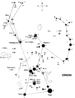
When you look in a sky atlas, you might see diagrams like this:
Obviously, this is very different from the photo above. This type of schematic draws the stars as different sizes to represent different brightnesses. In addition, there is a standard way to connect the stars that allow astronomers and others who use charts like this to quickly tell what they are looking at. In almost every star atlas, you will see Orion drawn with these same lines.
You might also notice that every star on the chart is labeled (sorry that it came out a little blurry). This chart is useful because it accurately shows the relative positions of the stars in this small region of the sky. In addition, other things besides stars are also labeled on the chart. For example, Barnard's Loop on the left and M42 in the bottom middle are pointed out. Barnard's Loop is a cloud of faintly glowing gas, which can't be seen without a telescope. M42 is the Great Orion Nebula and it is the red splotch in Orion's Sword in the photo above.


CONSTELACIONES

¿Qué son constelaciones?

Así, ¿cuáles son estas constelaciones de las que continuamos oyendo hablar? Tú puedes salir al exterior alguna noche y ver todo tipo de estrellas, y quizás tú incluso has observado el Big Dipper (hemisferio norte) y la Cruz del sur (hemisferio sur), pero ¿qué sobre Leo, el león o Piscis, el pez? ¿Qué sobre ellos?
La primera cosa que necesitas saber es que las constelaciones no son reales! Las constelaciones son cosas totalmente imaginarios que poetas, agricultores y astronautas han hecho a lo largo de los últimos 6000 años (¡y probablemente aún más!) El verdadero propósito de las constelaciones es que nos ayuden a saber que estrella es cada, nada más. En una noche realmente oscura, puedes ver cerca de 1000 a 1500 estrellas. Intentar decir cuál es cuál es difícil. Las constelaciones ayudan a romper el cielo en pedazos más manejables.
Ellas son usadas como memoria, o como ayuda de memoria.
Por ejemplo, si tú ves tres estrellas brillantes en línea (alineadas) en la tarde de invierno, puedes darte cuenta “Oh, esto es parte de Orión”. De repente la resta de la constelación se sitúa en su sitio (observas de repente la constelación entera) y tú puedes declarar: “Allí está Betelgeuse al hombro izquierdo de Orión y Rígel está a sus pies”. I la primera vez que reconoces Orión, puedes recordar que los Perros Cazadores de Orión, están siempre cerca. Entonces quizás puedas reconocer las dos estrellas brillantes en la parte superior i en la inferíos de la parte superior de la fotografía, y en la inferior Procyon en Canis Minor y Sinus en Canis Major, respectivamente.

Cuando miras el cielo de un atlas, tú quizás puedas ver diagramas como este:
Obviamente, esto es muy diferente de la foto superior. Este tipo de esquema dibuja las estrellas en diferente mida, tamaño, para representar su diferente brillo. Además, hay una manera estándar (general) de conectar las estrellas que permite a los astrónomos i a otros, los cuales usan gráficos como este para rápidamente decir hacia dónde están mirando.
En casi todos los atlas de estrellas, verás Orión dibujado con estas mismas líneas.
Quizás te des cuenta que todas las estrellas del gráfico están etiquetadas. Este gráfico es útil porque muestra acuradamente las relativas posiciones de las estrellas en esta pequeña región del cielo.


PLANETS

For the translation, the planets describe orbit around of Sunny. Each orbits is the year of planet. Each planet takes a time different for complete it. The furriest it is, the longer it takes. Turn almost in the same flat, excepting Pluto, that has the orbit more sloping, eccentric and elongated. The planets turn around of sunny, It hasn’t got light her, but that reflex the light solar .The planets has different movement. The must important is two: the rotation and the translation .For the rotation, it turn on itself around of axle. This determine the duration of day for the planet. The planets were formed 4500 millions a years ago, the same time that the sunny. In general, the materials light that don’t stay in the Sun move away more that the weight. In the cloud of gas and dust original, that around in spiral, had zones more density, projects of planets. The gravity and the coalition take more material to zones ¿The tenth planet in system solar? Sedna turnaround of Sun at a distance a lot bigger than other star of system. Although its size is still uncertain, Sedna is the bigger of planets locate around of Sun since the discovery of Pluto in 1930. That more of 10,000 millions of Kilometer of Land in a region called Kuiper Belt, that has hundreds of objects known, small world of rock and ice, although some can to be equally or more bigger than Pluto. Sedna is more that any other body of system solar, except Mart, and follow a orbit highly elliptical, that in her dot more remote site him to 135,000 millions of Kilometer of Sun. Therefore, Sedna need 11,500 years terrestrial. For complete an orbit.

PLANETAS


Los planetas giran alrededor del Sol. No tienen luz propia, sino que reflejan la luz solar.

Los planetas tienen diversos movimientos. Los más importantes son dos: el de rotación y el de translación. Por el de rotación, giran sobre sí mismos alrededor del eje. Ésto determina la duración del día del planeta. Por el de translación, los planetas describen órbitas alrededor del Sol. Cada órbita es el año del planeta. Cada planeta tarda un tiempo diferente para completarla. Cuanto más lejos, más tiempo. Giran casi en el mismo plano, excepto Plutón, que tiene la órbita más inclinada, excéntrica y alargada.

Formación de los planetas

Los planetas se formaron hace unos 4.500 millones de años, al mismo tiempo que el Sol.

En general, los materiales ligeros que no se quedaron en el Sol se alejaron más que los pesados. En la nube de gas y polvo original, que giraba en espirales, había zonas más densas, proyectos de planetas. La gravedad y las colisiones llevaron más materia a estas zonas y el movimiento rotatorio las redondeó Después, los materiales y las fuerzas de cada planeta se fueron reajustando, y todavía lo hacen. Los planetas y todo el Sistema Solar continúan cambiando de aspecto. Sin prisa, pero sin pausa.

¿El décimo planeta del Sistema Solar?

Sedna gira alrededor del Sol a una distancia mucho mayor que otros astros del sistema.

Aunque su tamaño aún es incierto, Sedna es el mayor de los planetas localizados alrededor del Sol desde el descubrimiento de Plutón en 1930. Está a más de 10,000 millones de kilómetros de la Tierra en una región llamada Cinturón de Kuiper, que tiene cientos de objetos conocidos, pequeños mundos de roca y hielo, aunque algunos pueden ser tan o más grandes que Plutón. Sedna es más rojo que cualquier otro cuerpo del Sistema Solar, excepto Marte, y sigue una órbita muy elíptica, que en su punto más alejado le sitúa a 135,000 millones de kilómetros del Sol. Por ello, Sedna necesita 11,500 años terrestres para completar una órbita.


dimarts, 15 de març del 2011

THE ASTEROIDS

The asteroids are rocky and metalic objects, that orbit arround
the Sun, but are too little for are considerate like planets. It know like minor planets, and it go arround in elipticals orbits, over all among the orbits of Mars and Jupiter. The size of the asteroids change since of Ceres, that have a diameter of a 1000 kilometer, until thesize of a pebble. Sixteen asteroids have got a diameter equal or higher to240 kilometer. It found since the inside of the orbit of the Earth until more there of the orbit of Saturn. The majority of it, however, it are contents in of the principal belt that exist among the orbits of mars and Jupiter. Some of it haveorbits that cross the trajectory of the earth and even some of it has crashed with our planets in the pased times. A of the betters examples preserve is the Crater Barringer near of Winslow, Arizona.
 
 Compotition 

The asteroids are constituite for the material that left over during theformation of the Solar sistem. A theory suggest that are the rests of a planet that was destroyed for a big collition do more time.Is more probable, how ever, the asteroids be the material thatit didn't arrive to unit for form a planet. If it take notice the total quantite of all the asteroids and it hold in aonly object, this object would have lesst than 1.500 diameters km.


LOS ASTEROIDES

Los asteroides son objetos rocosos y metálicos que orbitan alrededordel Sol pero que son demasiado pequeños para ser considerados como planetas. Se conocen como planetas menores, y giran en órbitaselípticas, sobre todo entre las órbitas de Marte y Júpiter. El tamaño de losasteroides tamaño de un guijarro. Dieciseis asteroides tienen un diámetro igual o superior a240 kilómevaría desde el de Ceres, que tiene un diámetro de unos 1000 kilómetros, hasta el tros. Se han encontrando desde el interior de la órbita de la Tierra hasta más allá de la órbita de Saturno. La mayoría, sin embargo, están contenidos dentro del cinturón principal que existe entre las órbitas de Marte y Júpiter. Algunos tienenórbitas que atraviesan la trayectoria de la Tierra e incluso algunos han chocado connuestro planeta en tiempos pasados. Uno de los ejemplos mejor conservados es el Cráter Barringer cerca de Winslow, Arizona.


Composición


Los asteroides están constituidos por el material que sobró durante la formación del sistema solar. Una teoría sugiere que son los restos de un planeta que fue destruido por una gran colisión hace mucho tiempo. Es más probable, sin embargo, que los asteroides sean el material que no llegó nunca a aglutinarse para formar un planeta. Si se tiene en cuenta la masa total de todos los asteroides y se concentra en unsolo objeto, este tendría menos de 1.500 kilómetros de diámetro

dilluns, 28 de febrer del 2011

THE LAYERS OF THE EARTH

Earth cutaway from core to exosphere. The interior structure of the Earth, similar to the outer, is form for three layers. These layers can be defined by their chemical properties. The Earth has an outer solid crust, a viscous mantle, a liquid outer core that is much less viscous than the mantle, and a solid inner core. Scientific understanding of Earth's internal structure is based on observations of topography, observations of rock in outcrop, samples brought to the surface from greater depths by volcanic activity, analysis of the seismic waves that pass through the Earth, measurements of the gravity field of the Earth, and experiments with crystalline solids at pressures and temperatures characteristic of the Earth's deep interior.
The estructure of the Earth can be defined in two parts different. It composition chemically, the Earth can be divided in crust, mantle, inner core and outer core. And its propertys phisica are defined  the lithosphere, the asthenodphere, the mesosphere and the core. 

Depth
Layer
Kilometers
Miles
0–60
0–37
Lithosphere (locally varies between 5 and 200 km)
0–35
0–22
Crust (locally varies between 5 and 70 km)
35–60
22–37
… Uppermost part of mantle
35–2,890
22–1,790
100–200
62–125
35–660
22–410
… Upper mantle
660–2,890
410–1,790
… Lower mantle
2,890–5,150
1,790–3,160
5,150–6,360
3,160–3,954


LAS CAPAS DE LA TIERRA

La Tierra está cortada desde el núcleo a la superficie . La estructura interior de la Tierra, parecida a la exterior, está formada por tres capas. Estas capas pueden estar definidas por sus propiedades químicas. La Tierra tiene una corteza sólida exterior, un manto viscoso, el núcleo exterior es líquido. El núcleo exterior es más viscoso que el manto, i un núcleo interior sólido. Los científicos entienden que la estructura interna de la Tierra està basada en observaciones topográficas, observaciones de rocas en la parte externa de la corteza, ejemplos llevados a la superfície  de grandes profundidades de actividades volcánicas, analisis de las onas de los terremotos que passan a la Tierra, mesuramientos de los campos de gravedad de la Tierra, y experimentos con sólidos cristalinos en presiones y temperaturas características de la capa interior de la Tierra.
La estructura de la tierra puede establecerse en dos partes diferentes. Su composición química, el planeta puede dividirse en corteza, manto y núcleo. Y sus propiedades físicas se definen la litosfera, la astenosfera, la mesosfera y el nucleo.
Capa
Profundidad (km)
Litosfera (varía localmente entre 5 y 200 km)
0 – 60
... Corteza (varía localmente entre 5 y 70 km)
0 – 35
... Parte superior del manto
35 – 60
35 – 2 890
Manto superior
35 – 660
100 – 200
Manto inferior (Mesosfera)
660 – 2 890
Núcleo externo
2 890 – 5 100
Núcleo interno
5 100 – 6 378


diumenge, 20 de febrer del 2011

PLATE TECTONICS


Scientists known as oceanographers have been able to measure the earth of our planet. These scientists have discovered the plate tectonics theories that have helped to explain how it is that continents are been able to move around on the Earth’s crust. Deep beneath the waves, at the surface of the ocean, located almost exactly halfway between the continents are raised areas known as ridges. These ridges are similar to under-water of mountain and ranges. At other locations we find extremely deep trenches, some reaching many thousands of feet in depth. Many scientists believe that the ridges represent areas where crust is being formed, as hot magma escapes from the Earth’s core, and spreads the earth’s curst. As the seafloor outward, away from the area where magma is being released, the continents are carried across the sea The plates are all moving in different directions and at different speeds (from 2 cm to 10 cm per year--about the speed at which your fingernails grow) in relationship to each other. The plates are moving around like cars in a demolition derby, which means they sometimes crash together, pull apart, or sideswipe each other. The place where the two plates meet is called a plate boundary. Boundaries have different names depending on how the two plates are moving in relationship to each other.
·        - Crashing: Convergent Boundaries, These convergent boundaries also occur where a plate of ocean dives, in a process called subduction, under a landmass. As the overlying plate lifts up, it also forms mountain ranges. In addition, the diving plate melts and is often spewed out in volcanic eruptions such as those that formed some of the mountains in the Andes of South America. 
·       -  Pulling apart: Divergent Boundaries, At divergent boundaries in the oceans, magma from deep in the Earth's mantle rises toward the surface and pushes apart two or more plates. Mountains and volcanoes rise along the seam. The process renews the ocean floor and widens the giant basins. A single mid-ocean ridge system connects the world's oceans, making the ridge the longest mountain range in the world.
 -Or sideswiping: Transform Boundaries : the San Andreas Fault in California is an example of a transform boundary, where two plates grind past each other along what are called strike-slip faults. These boundaries don't produce spectacular features like mountains or oceans, but the halting motion often triggers large earthquakes, such as the 1906 one that devastated San Francisco.

Currently there are 14 main plates and many smaller subplates. The main plates are:
         
         Pacific plate                                              ·        
         
          Juan de Fuca plate
·         North American plate
·         South American plate
·         Caribbean plate
·         Cocos plate
·         Nazca plate
·         Scotia plate
·         Antarctica plate
·         African plate
·         Arabian plate
·         Eurasian plate

·         Indian-Australian plate

·         Philippine plate


PLACAS TECTÓNICAS
 

Los científicos conocidos como oceanógrafos han podido mesurar la tierra de nuestro planeta. Estos científicos han descubierto la teoría de las placas tectónicas que ha ayudado a explicar como es que los continentes se pueden mover por la corteza de la Tierra. Muy profundo debajo las olas, en la superfície de los oceanes, situado casi exactamente medio camino entre los continentes se levantan areas conocidas como crestas o carenas. Estas carenas son similares a bajo las aguas de las montañas y serraladas. En otras localicaciones nosotros encontramos profundas trincheras ,algunas llegan muchos miliones de pies en profundidad.Muchos científicos creen que las carenas representan áreas donde la corteza es formada, como el caliente magma escapa de la superficie de la tierra, y extienden la corteza de la Tierra, como la Tierra de los mares es externa lejanos de el área dondde el magma se realiza, los continentes son cargados a través del mar. Las placas se mueven en diferentes direcciones y ha diferentes velocidades (de 2 cm a 10 cm por año - cerca de la velocidad con que crecen las uñas) en relación la una a la otra. Las placas se mueven como los coches en un derby de demolición, lo que significa que a veces chocan entre sí, se separan, o de colisión lateral entre sí. El lugar donde las dos placas se encuentran se llama un límite de placa. Los límites tienen nombres diferentes en función de cómo las dos placas se mueven en relación a otra.


-Choque: convergente límites, estos límites convergentes también se producen en una placa de inmersiones en el mar, en un proceso llamado subducción, en virtud de una masa de tierra. A medida que la placa superior se levanta, que también forma las cordilleras. Además, la placa de buceo se funde y con frecuencia se arrojó en erupciones volcánicas, como las que se formaron algunas de las montañas en los Andes de América del Sur.
- Separando: Límites divergentes, En los límites divergentes en los océanos, el magma se eleva desde la profundidad de manto de la Tierra hacia la superficie y además lleva dos o más placas. Montañas y volcanes lugar a lo largo de la costura. El proceso se renueva el fondo del océano y amplía las cuencas gigantes. Un sistema único en medio del océano canto conecta los océanos del mundo, por lo que la cresta de la cordillera más larga del mundo.
-O rozandose : Transformar las fronteras: la falla de San Andrés en California es un ejemplo de un límite de transformación, donde dos placas de moler más allá de nosotros a lo largo de lo que se llaman fallas de desgarre. Estos límites no producen características espectaculares como montañas o en los océanos, pero el movimiento detener suele provocar grandes terremotos, como el 1906 que devastó San Francisco.
Actualmente hay 14 placas principales y muchas placas base más pequeñas. Las placas principales son:


-Placa pacífica
-Placa de Juan de Fuca
-Placa de nord amèrica
-Placa de sud amèrica
-Placa del caribe
-Placa de nazca
-Placa de escocia
-Placa de africa
-Placa de cocos
-Placa d’Antartica
-Placa arabica
-Placa euroasiática
-Placa filipina
-Placa indoastrauliana